

Executive Summary
In response to Hurricane Katrina, I led a fundraiser selling "fancy" telescopes (construction paper rolled up with stickers and glitter on them) at my first grade parent-teacher conferences. I raised $108, which I was very proud of at the time.
Years later, despite an improved technological landscape and my $108, the Hurricane Response process is not significantly more efficient.
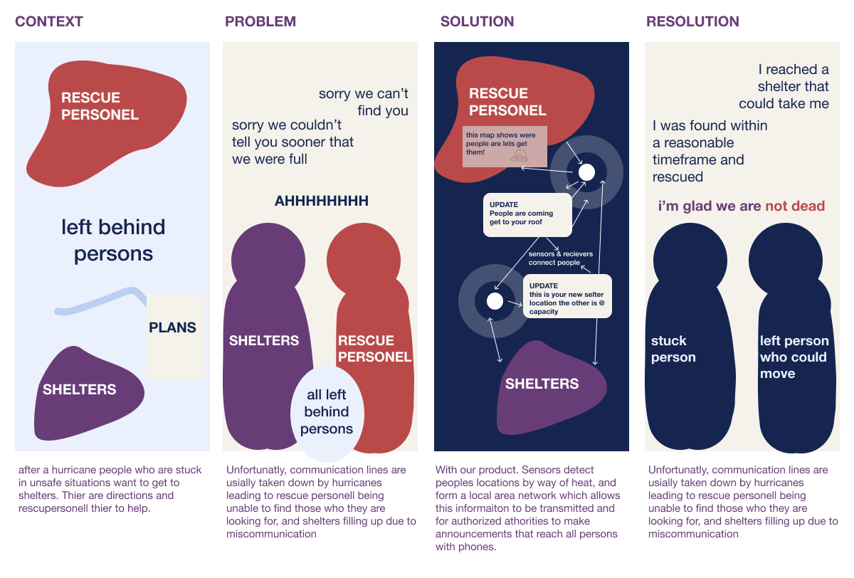
When hurricanes come, people who need evacuation struggle to be located and rescued, and those who need shelter find themselves being turned away due to poor communication.
From outside research, interviews with crisis management personnel, and discussions with engineers, we designed Hurri Safe to tackle the critical communication challenge.
Hurri Safe is a module that creates a local network to enable communication from officials to those left on the ground and maps heat created by people to allow officials to identify the locations of those left behind. Unlike the current system, this enables dynamic decisions and increases the rescue window to include the day's low-visibility times.
Because hurricane rescue is such a time-sensitive and pressing issue, we hypothesize that the increased communication enabled by Hurri Safe modules would lead to more efficient hurricane rescue.
This project yielded the concept video above.
Teammates
Ekta Verma (MHCI 2020)
Ketaki Rao (MHCI 2020)
Megan Parisi (MHCI 2020)
My Role
As a designer, I edited video (including all audio work), wrote and found clips for the intro, designed all animations in the walkthrough, created the logo and served as narrator. Doing design work on this project enabled me to hone my storytelling abilities.
As a researcher, I acquired an interview with a person who works with Hurricane Response to ensure that our suggestions were reasonable and to gather more information and led research on scanning types to discover the info-red sensor. This process was the first time I considered physical requirements for an IoT design, which opened my eyes to more design possibilities for the future. Moreover, the more extensive contextual and high-stakes nature of this problem challenged me to focus on accuracy and systems thinking as I moved into design.
As a teammate, I used my knowledge of video production to set accurate achievable timelines and delegate work.
.
Problem
Hurricane rescue is currently dangerously inefficient, with many left behind and left confused about where their appropriate shelter was. This mismanagement of rescue resources has been devastating to communities and will continue until the system is changed.
Our research uncovered that this pain's primary root is the inability to communicate to those who need help and are providing it, as hurricanes take out natural power lines.
With this project, we tried to answer the question of:
How might we make hurricane rescue more efficient with technology?
Process
Tactics.
Interview, Storyboarding (Both Design & Film Style), Technical Research, Critique, Journey Mapping, Persona Building.
Narrowing Scope.
Since we began with such a broad prompt (create a solution to a societal problem that uses IoT), we started brainstorming ideas in many spaces and scales. We tested a set of concepts with classmates and decided to explore a large-scale area with many public records for research.
As you hopefully guessed, we decided to tackle hurricane rescue in the United States.
Now, only half of my group was from the US, and none of us were from a state typically hit by hurricanes, so we split up to broadly understand these systems without relying on personal experience.
We began background research explicitly seeking to understand the key players and events of a US hurricane response.
Understanding the Space.
Key Players
We first noticed two distinct types of victims, with needs defined by their mobility levels.
The stuck person — cannot leave their house due to water levels and rely on rescue persons to find them. Their central pain point is their inability to contact rescue persons to get rescued and the stress of not knowing if or when they will be saved.
The active shelter seeker — this person has more agency. They are often able to move and drive to different shelters for help. Their main problem is understanding how to access resources available, as information about changes or capacity relayed in a delayed manner to them.
.

.
These victim types are each supported by different support systems.
The first type of support is rescuers for the stuck people.
The official state/national rescuer — They attempt to rescue every person as quickly as possible. Their main issue is an inability to locate persons. They often have their hours reduced due to not being able to see at night.
The unofficial rescuer— recognizing prior inefficiencies in the system, this person goes out of their way to rescue others. They often use jet-ski’s of their own and rely on word of mouth to learn locations. This person can save stuck individuals one at a time. Their challenges are a lack of access to official information, an inability to see well in the dark, and lower rescue capacity than authorized personnel.
The second group handles shelters. While many different persons play roles in the shelter allocation process, there is only one relevant role for this problem.
The on-site shelter communications coordinators — These persons attempt to ensure that shelters are open and run smoothly. They compare attendance and capacity. They were communicating to news and officials to schedule any necessary adjustments. They struggle to communicate changes and feel guilty about providing incorrect information.
Critical Insights: In analyzing the key players and the system, it was clear that a communication gap during these events hurt each person. A solution for this scenario must address this vital issue for both the stuck and active shelter-seeking paths.
.
Key Events
After creating personas for each group, we then made journey maps to understand better where problems lay.
In comparing across journey maps, we found that the critical point of distress was when power lines get knocked out and cut off communication.
Additionally, we identified the moment of shelter overflow as a critical point in the active shelter seeker journey and identification as an essential part of the stuck person’s journey.
Finally, we identified the 72hr mark as vital, as hurricane rescuers strive to get every stuck person rescued by that point.
Identifying Solution Requirements
With this understanding, we drafted a set of requirements for a viable solution that would tackle the situation's communication and logistical issues.
- Must support both active shelter seekers and stuck people.
- Must be able to work with networks down.
- Must provide communication between survivors and officials.
- Must be able to track people without GPS devices.
- Must be able to run for 72hrs without charging.
- Must be waterproof.
.
With this design. we created a storyboard of a solution to test with classmates to see if it made sense.
.
Response to our storyboard was overwhelmingly positive. However, the people who we were testing on did not have familiarity with this topic or experience so I reached out to someone who was more familiar with the topic.
Getting feedback from domain experts.
I reached out to my friend who's sister had studied emergency planning and she pit us in contact with someone who deals directly with this scenario.
The key insight from this interview, was that we needed to think more about deployment and ability to not be destroyed by storm surges, a factor that we had not considered.
Given this information, we updated our criteria for an ideal solution to include a third item: heavy enough to not be disturbed by storm surges.
Updating our design for durability.
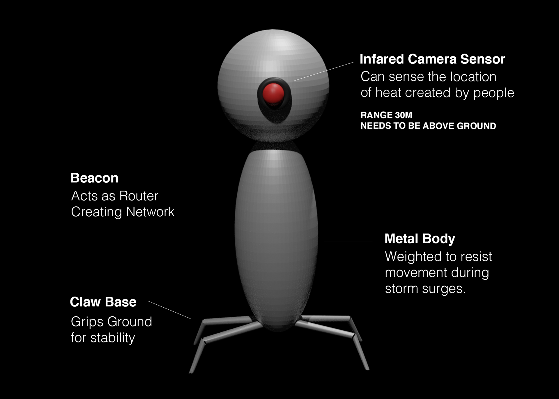
We imagined that this would allow the Infrared Camera Sensor to work. These ideas were cross checked by a group of engineers.
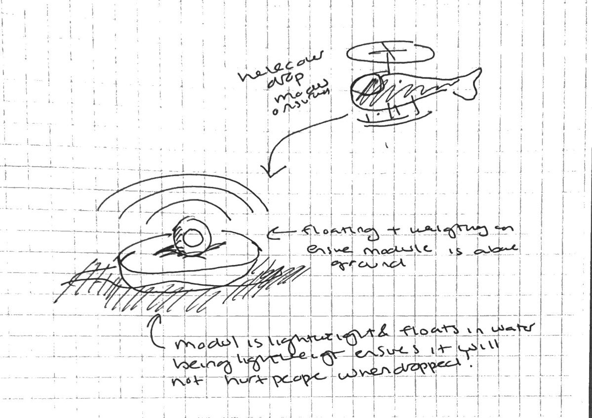
For deployment, we imagined that these could be deployed using weather proof drones from helicopters, as they are storm resistant and helicopters are already being used, and have been purchased for post-hurricane recovery.
Solution
Our solution, Hurri Safe, is a tiny module dropped from planes on drones planes and will dig into the ground using its claws, which will help keep the module steady during storm surges.
Once it lands, it creates a local area network that will allow those within the area to receive alerts on their phones from officials about evacuation times, shelter directions, & capacity updates. Additionally, the infrared sensor on the module scans the area for heat, a reasonably good representation of people enabling officials to optimize their rescue routes better and increase the time when they can carry out rescues to include dark hours.
In summary, creating a local area network and scanning for heat Hurri Safe can improve the efficiency and effectiveness of all important hurricane rescue missions.
(Watch the video above to see the steps in action)